Desarrollo del imperio británico, litografía, publicado en 1897 - Ilustración de stock
Map of the territorial development of the British Empire from the 17th century to the end of the 19th century. Lithograph, published in 1897.

COMPRAR LICENCIA
Todas las licencias libres de derechos incluyen derechos de uso mundiales, protección completa y precios sencillos con descuentos por volumen.
AR$ 208.500,00
ARS
Getty ImagesDesarrollo Del Imperio Britnico Litografa Publicado En 1897, Foto de stock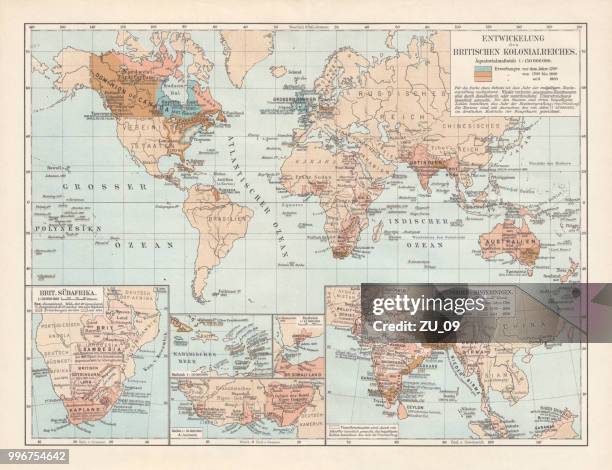 Descarga ilustraciones de stock de Desarrollo del imperio británico, litografía, publicado en 1897 auténticas y de calidad premium de Getty Images. Explora ilustraciones de stock de alta resolución similares en nuestro extenso catálogo visual.Product #:996754642
Descarga ilustraciones de stock de Desarrollo del imperio británico, litografía, publicado en 1897 auténticas y de calidad premium de Getty Images. Explora ilustraciones de stock de alta resolución similares en nuestro extenso catálogo visual.Product #:996754642AR$208.500AR$35.500
Getty Images
In stockDETALLES
Crédito:
Creative n.º:
996754642
Tipo de licencia:
Colección:
DigitalVision Vectors
Tamaño máx. archivo:
8070 x 6195 px (68,33 x 52,45 cm) - 300 dpi - 47 MB
Fecha de subida:
Ubicación:
Germany
Inf. de autorización:
No se precisa autorización
Categorías:
- Mapa,
- Reino Unido,
- Imperio Británico,
- Colonialismo,
- Imperialismo,
- India,
- Mapa mundial,
- Cultura británica,
- Siglo XVII,
- Europa - Continente,
- Colonial,
- Inglaterra,
- América del norte,
- Colonia - Grupo de animales,
- Mapa topográfico - Cartografía,
- Siglo XVIII,
- Imperio,
- Siglo XIX,
- América Central,
- Cultura inglesa,
- África,
- Alemania,
- América del Sur,
- Asia,
- Australia,
- Azul,
- Blanco - Color,
- Capitalismo,
- Colorido,
- Crecimiento,
- Desarrollo,
- El pasado,
- Estilo victoriano,
- Grabado - Objeto fabricado,
- Hispanoamérica,
- Historia,
- Horizontal,
- Ilustración,
- Litografía,
- Marrón,
- Paisaje no urbano,
- República de Sudáfrica,